![](/images/other/stat-length.png)
![Randonnée Marche La Ferté-Vidame - Tour des Collines du Perche 4 - Photo](https://media.geolcdn.com/t/1900/400/ext.pjpeg?maxdim=2&url=https%3A%2F%2Fstatic1.geolcdn.com%2Fsiteimages%2Fupload%2Ffiles%2F1553511878bg_sport_marche.png)
Tour des Collines du Perche 4
togolo28
Utilisateur
![Longueur](/images/other/stat-length.png)
Longueur
30 km
![Altitude max](https://static1.geolcdn.com/siteimages/upload/files/1508320355ic_sort_altitude_max_24dp.png)
Altitude max
296 m
![Dénivelé positif](https://static1.geolcdn.com/siteimages/upload/files/1508320355ic_sort_den_pos_24dp.png)
Dénivelé positif
328 m
![Km-Effort](/images/other/stat-length.png)
Km-Effort
34 km
![Altitude min](https://static1.geolcdn.com/siteimages/upload/files/1508320355ic_sort_altitude_min_24dp.png)
Altitude min
212 m
![Dénivelé négatif](https://static1.geolcdn.com/siteimages/upload/files/1508320355ic_sort_den_neg_24dp.png)
Dénivelé négatif
315 m
![Boucle](https://static1.geolcdn.com/siteimages/upload/files/16400158638029165_repeat_loop_refresh_sync_direction_icon.png)
Boucle
Non
Date de création :
2016-10-18 00:00:00.0
Dernière modification :
2016-10-18 00:00:00.0
![Marche](https://static1.geolcdn.com/sitytour/trail-icons/101.png)
7h19
Difficulté : Difficile
![Scannez ce code QR pour ouvrir la randonnée dans l'application SityTrail](https://capi.geolives.com/qq0zvz2zws4bq2lad0pu/sitytour/trails/430723/qr.png?size=200)
Application GPS de randonnée GRATUITE
À propos
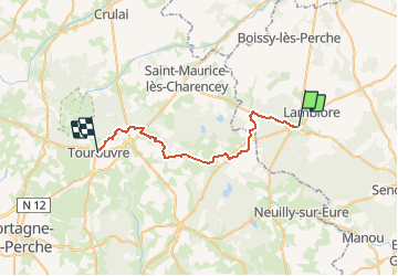
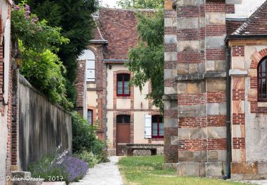
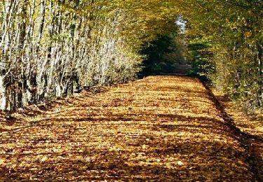
Randonnée Marche de 30 km à découvrir à Centre-Val de Loire, Eure-et-Loir, La Ferté-Vidame. Cette randonnée est proposée par togolo28.
Description
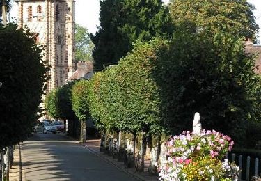
Le Tour des Collines du Perche à été réalisé par l'association « Itinéraires Ruraux » de Pervenchères (orne).
Vous pouvez consulter leur site internet :
http://itinerairesduperche.org
Localisation
Pays :
France
Région :
Centre-Val de Loire
Département/Province :
Eure-et-Loir
Commune :
La Ferté-Vidame
Localité :
Unknown
Départ:(Dec)
Départ:(UTM)
345256 ; 5386411 (31U) N.
Commentaires
Randonnées à proximité
![Randonnée Marche La Ferté-Vidame - La Ferté-Vidame - Longny-au-Perche (Longny-les-Villages) 23 km - Photo](https://media.geolcdn.com/t/375/260/5ed99afd-b5c6-42e1-9343-ce75df697bb2.jpg&format=jpg&maxdim=2)
![Marche Marche](https://static1.geolcdn.com/sitytour/trail-icons/101.png)
La Ferté-Vidame - Longny-au-Perche (Longny-les-Villages) 23 km
Marche
Très difficile
La Ferté-Vidame,
Centre-Val de Loire,
Eure-et-Loir,
France
![](/images/other/stat-length.png)
23 km | 25 km-effort
5h 35min
![](https://static1.geolcdn.com/siteimages/upload/files/16400158638029165_repeat_loop_refresh_sync_direction_icon.png)
Non
![Randonnée Marche La Ferté-Vidame - La Ferté-Vidame - Tourouvre (TCP) 29 km - Photo](https://media.geolcdn.com/t/375/260/d98149be-773b-466c-b336-70c46d69328d.jpg&format=jpg&maxdim=2)
![Marche Marche](https://static1.geolcdn.com/sitytour/trail-icons/101.png)
La Ferté-Vidame - Tourouvre (TCP) 29 km
Marche
Moyen
La Ferté-Vidame,
Centre-Val de Loire,
Eure-et-Loir,
France
![](/images/other/stat-length.png)
29 km | 33 km-effort
7h 9min
![](https://static1.geolcdn.com/siteimages/upload/files/16400158638029165_repeat_loop_refresh_sync_direction_icon.png)
Non
![Randonnée Marche La Ferté-Vidame - La Ferté-Vidame - Moutiers-au-Perche (TCP) 28 km - Photo](https://media.geolcdn.com/t/375/260/17f1064c-f2d0-4388-8493-f7f18ee11920.jpg&format=jpg&maxdim=2)
![Marche Marche](https://static1.geolcdn.com/sitytour/trail-icons/101.png)
La Ferté-Vidame - Moutiers-au-Perche (TCP) 28 km
Marche
Facile
La Ferté-Vidame,
Centre-Val de Loire,
Eure-et-Loir,
France
![](/images/other/stat-length.png)
28 km | 32 km-effort
7h 1min
![](https://static1.geolcdn.com/siteimages/upload/files/16400158638029165_repeat_loop_refresh_sync_direction_icon.png)
Non
![Randonnée Marche La Ferté-Vidame - La Ferté-Vidame - Saint-Maurice-lès-Charencey 15 km - Photo](https://media.geolcdn.com/t/375/260/6ed3707c-f3e2-46d2-9930-16239d79219c.jpg&format=jpg&maxdim=2)
![Marche Marche](https://static1.geolcdn.com/sitytour/trail-icons/101.png)
La Ferté-Vidame - Saint-Maurice-lès-Charencey 15 km
Marche
Facile
(1)
La Ferté-Vidame,
Centre-Val de Loire,
Eure-et-Loir,
France
![](/images/other/stat-length.png)
15,3 km | 16,9 km-effort
3h 34min
![](https://static1.geolcdn.com/siteimages/upload/files/16400158638029165_repeat_loop_refresh_sync_direction_icon.png)
Non
![Randonnée Marche La Ferté-Vidame - La Ferté Vidame 07.86 - Photo](https://media.geolcdn.com/t/375/260/ext.jpg?maxdim=2&url=https%3A%2F%2Fstatic1.geolcdn.com%2Fsiteimages%2Fupload%2Ffiles%2F1553511878bg_sport_marche.png)
![Marche Marche](https://static1.geolcdn.com/sitytour/trail-icons/101.png)
La Ferté Vidame 07.86
Marche
Facile
(1)
La Ferté-Vidame,
Centre-Val de Loire,
Eure-et-Loir,
France
![](/images/other/stat-length.png)
8,2 km | 9,1 km-effort
1h 58min
![](https://static1.geolcdn.com/siteimages/upload/files/16400158638029165_repeat_loop_refresh_sync_direction_icon.png)
Oui
![Randonnée Marche La Ferté-Vidame - La Ferté-Vidame - Senonches 17 km - Photo](https://media.geolcdn.com/t/375/260/dc48b6f8-8e0a-4753-a60e-6bc96e6543fb.jpg&format=jpg&maxdim=2)
![Marche Marche](https://static1.geolcdn.com/sitytour/trail-icons/101.png)
La Ferté-Vidame - Senonches 17 km
Marche
Facile
La Ferté-Vidame,
Centre-Val de Loire,
Eure-et-Loir,
France
![](/images/other/stat-length.png)
16,7 km | 18,5 km-effort
4h 36min
![](https://static1.geolcdn.com/siteimages/upload/files/16400158638029165_repeat_loop_refresh_sync_direction_icon.png)
Non
![Randonnée V.T.T. La Ferté-Vidame - Autour de la forêt (Etape 1) - La Ferté-Vidame - Photo](https://media.geolcdn.com/t/375/260/ext.jpg?maxdim=2&url=https%3A%2F%2Fservices.sitytrail.com%2FGeolivesWS%2FDownloadMedia.ashx%3FTrailID%3D172714%26Media%3D14101_2.jpg)
![V.T.T. V.T.T.](https://static1.geolcdn.com/sitytour/trail-icons/202.png)
Autour de la forêt (Etape 1) - La Ferté-Vidame
V.T.T.
Moyen
(1)
La Ferté-Vidame,
Centre-Val de Loire,
Eure-et-Loir,
France
![](/images/other/stat-length.png)
19,5 km | 22 km-effort
2h 0min
![](https://static1.geolcdn.com/siteimages/upload/files/16400158638029165_repeat_loop_refresh_sync_direction_icon.png)
Non
![Randonnée Marche La Ferté-Vidame - Autour de la forêt (Etape 1) - La Ferté-Vidame - Photo](https://media.geolcdn.com/t/375/260/ext.jpg?maxdim=2&url=https%3A%2F%2Fservices.sitytrail.com%2FGeolivesWS%2FDownloadMedia.ashx%3FTrailID%3D172713%26Media%3D14101_5.jpg)
![Marche Marche](https://static1.geolcdn.com/sitytour/trail-icons/101.png)
Autour de la forêt (Etape 1) - La Ferté-Vidame
Marche
Difficile
La Ferté-Vidame,
Centre-Val de Loire,
Eure-et-Loir,
France
![](/images/other/stat-length.png)
19,5 km | 22 km-effort
5h 19min
![](https://static1.geolcdn.com/siteimages/upload/files/16400158638029165_repeat_loop_refresh_sync_direction_icon.png)
Non
![Randonnée Vélo La Ferté-Vidame - La Chapelle de Réveillon - La Ferté Vidame - Photo](https://media.geolcdn.com/t/375/260/ext.jpg?maxdim=2&url=https%3A%2F%2Fservices.sitytrail.com%2FGeolivesWS%2FDownloadMedia.ashx%3FTrailID%3D129911%26Media%3D13463_6.jpg)
![Vélo Vélo](https://static1.geolcdn.com/sitytour/trail-icons/200.png)
La Chapelle de Réveillon - La Ferté Vidame
Vélo
Facile
La Ferté-Vidame,
Centre-Val de Loire,
Eure-et-Loir,
France
![](/images/other/stat-length.png)
16,7 km | 18,5 km-effort
2h 0min
![](https://static1.geolcdn.com/siteimages/upload/files/16400158638029165_repeat_loop_refresh_sync_direction_icon.png)
Oui